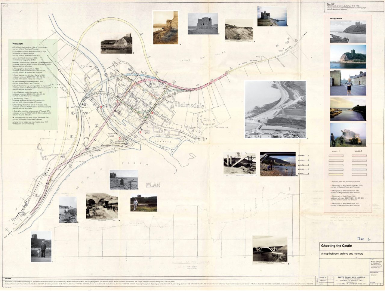
Ghosting the Castle focused on the layered histories and issues related to Helmsdale’s medieval castle and the A9 bridge which replaced it. These have been investigated through the archives of Timespan, National Records of Scotland and Historic Environment Scotland, alongside collected memories and knowledge of the site.
This map is the result of talking and walking between archive and memory. It is both artwork and document, a lasting reminder of a transient site-specific project and its research process. Starting with Timespan’s Archive, Helmsdale’s people and the story of a castle demolished to make way for the A9 bridge, it unfolds to reveal a plan from 1967. The plan shows five options for a new bridge to take the pressure off Helmsdale’s old bridge, which had been seriously weakened by heavy traffic. At this time, the ruined castle – a scheduled monument since 1940 – had been undermined by years of coastal erosion and was crumbling into the sea. The plan is the only archival document where the castle and the new bridge are represented together.
Photographs from personal and public archives have been added to the original plan. Personal photographs combine references to individual and cross-generational memories of people and place in which the castle was a distinct feature, with other photographs that more formally document the process of major change.
A concrete stone now marks the castle’s existence in Couper Park car park, where an information board describes an infamous 16th-century murder by poisoning that took place in the castle. Yet visitors to the marker might find it difficult to get a sense of the castle’s scale and actual location, where the ruin once stood 24 feet high on 7 metres of land now removed. The Canmore grid reference ND 0272 1515 places the castle across the A9 Bridge, halfway down an embankment towards the sea. Other clues to a past landscape lie in the present-day location, such as the stepped pathway that drops down from the Emigrants Monument to the car park, showing the extent of land removed. Yet even recognising such features as clues to the castle’s location can be challenging.
One of the map’s five numbered vantage points is marked here. The corresponding photographs for the vantage points are all from Timespan’s Archive. These also mark the spot where each image can be viewed from a vintage Kodak Viewfinder on location, as part of Ghosting the Castle’s closing guided walk event (16 September 2017). For a short period, the castle is placed back into Helmsdale’s landscape.
Helmsdale Castle still has a place within living memory. Childhood memories for some are still vivid: a stage set up inside the castle to dance on; a climb up to look through a window; throwing the castle’s stones over the cliff; and, on days when frost began to thaw, fishermen hearing parts of castle and cliff fall into the sea. For others, memories of the castle in its final years are less clear – ‘it was just there’ – until the A9 bridge finally took its place. Between archive and memory, the story of the ruined castle and its demolition also raises other questions of heritage, conservation and sustainability.
Ghosting the Castle, 1st Edition, 2017; 2nd Edition, 2018
An edition of nine fold-out maps, OS Landranger size 1000 x 753 mm
Design and layout by Chris Taylor, Wild Pansy Press
Printed by Dennis Maps Ltd
Related Posts
Bird, Nicky. Ghosting the Castle: the case of relandscaping a Northern Place, 2020
Bird, Nicky. Ghosting the Castle, 2017
TOP IMAGE: Ghosting the Castle – A Map between Archive and Memory (full fold-out) by Nicky Bird, 2017